Lets Talk African History: Ancient Nubia

Misreeya

Pro
Joined
Jun 13, 2015
Messages
1,663
Reputation
-90
Daps
2,135
Reppin
Sudan/New Zealand.

a2a5b24d217da82144ced60d73a63a4d.jpg


Excavation and survey at Kawa


respro_kawa_body_view_624x352.jpg

A view over the ancient town looking north along the River Nile.


heathcote_07_77.jpg


The town
Kawa covers an area of approximately 40 hectares on the east bank of the Nile enjoying fine views along the river. During the topographical survey the remains of many buildings were noted immediately beneath the sand and by brushing the surface many structures could be planned.

Where the buildings were more deeply buried a fluxgate gradiometer (an instrument which measures variations in the magnetic field below the ground) was used. Mud-brick walls made from iron-rich sediments give a high magnetic signal, sand gives a low signal. By this means the positions of buried walls can be plotted, enhancing our understanding of the town plan. Over much of the site there appears to be a dense arrangement of buildings with clearly defined streets between them.


Houses
Several houses and adjacent streets have been excavated towards the centre of the town. The houses were rectilinear, well constructed with substantial mud-brick walls but few internal fittings beyond hearths and ceramic cylindrical bread ovens set on floors of sand or earth.

Interiors were kept clean; discrete piles of rubbish in the streets adjacent to the house walls indicate the location of windows out of which the rubbish was thrown. As rooms went out of use they were utilised as rubbish dumps yielding a rich haul of pottery and food detritus.

respro_kawa_house_2_304x176.jpg

Excavating houses with the help of men from the local village of Kasura.

respro_kawa_house_304x176.jpg

A typical multi-roomed house with walls of mud brick.


Shrine
At the southern end of the ancient town a three-roomed shrine was found. The easternmost room was the sanctuary and was floored with thick and large white sandstone slabs on which rested a stone altar bearing the painted cartouches of Taharqo. All the internal walls were covered in painted scenes on the mud plaster with its whitewashed surface. Flanking the doorway into the sanctuary were two hieroglyphic inscriptions, ‘beloved of Amun of Thebes’ on the north side and ‘beloved of Amun of Gematon’ on the south side. Over the door was a lintel decorated with a fine painted winged sundisc with uraei in bright reds, yellows and blues.

In the central room the king wearing fine golden sandals approaches a blue-painted Amun with two elegant goddesses behind. Outside the building stood a mud-brick altar which still retained the remains of burnt offerings from the last sacrifice on its top. Over time the building, originally entered up a step, was then entered down a sloping ramp and a flight of three steps as the sand inexorably began to cover the building. The external altar disappeared first, the rest of the building vanishing beneath the sand well before the abandonment of the town.

respro_kawa_body_painting_304x176.jpg

Wall painting with representations of a god and goddess and the lower part of an inscription in Egyptian hieroglyphs '.... beloved of Amun of Thebes'

respro_kawa_body_painting_2_304x176.jpg

A painted wall depicting the king on the left before a blue-painted Amun and two goddesses.


Industrial quarter
Two kilns have been excavated, both of very similar form. They are rectangular and set into the ground to a depth of almost two metres. Parallel walls only 380 millimetres apart cross the kiln’s short axis, pierced by tall arches. At each end a ramp slopes down to the arched stokeholes. Fire set inside the stokeholes will have heated up the interior. Passing through the large arches the heat penetrated into the body of the kiln through holes in its floor. Resting on that floor will have been the payload but what that may have been is unclear.

It is likely, but unproven, that these were brick kilns; the technology appears to have been imported from the Roman Empire to the north.

respro_kawa_body_kiln_work_304x176.jpg

A kiln under excavation.

respro_kawa_body_kiln_work_2_304x176.jpg

General view of Kiln F7 with the cross walls pierced by arches.


The cemetery
Where the inhabitants of the pharaonic Egyptian town buried their dead has yet to be ascertained. The Kushyte cemetery lies several hundred metres to the east of the town across the desert and is of similar extent to the town itself. Graves have been excavated in several areas across the cemetery. The most common burial type has an extended inhumation placed on its back aligned west–east, that is with the head to the west. The body lies in a chamber hollowed out of the alluvium entered through a doorway from the base of a stairway cut into the earth. Following burial the doorway was blocked with a mud-brick wall, the stairway infilled and a tomb monument built on top, a pyramid, mastaba or tumulus.

In the north-eastern part of the cemetery were elite graves with large stone pyramids of similar or even greater size than those of the contemporary kings of Kush at Meroe. Here the large tombs were of stone and barrel-vaulted.

respro_kawa_body_doorway_304x176.jpg

Elaborate stone doorway leading into a barrel-vaulted tomb under one of the large pyramids at Kawa.

respro_kawa_body_kiln_304x176.jpg

An extremely small pyramid, only about 2.5m square at the base, built of dressed sandstone blocks with a rubble core.


The finds
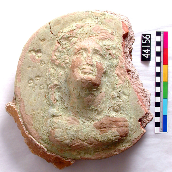
A wealth of pottery has been recovered from the site offering a wide range of data on the function of space, on modes of food preparation and consumption, on trade, technology and artistic trends. The most impressive single piece is not actually Kushyte at all, but a Roman table amphora made in Campania between the first century BC and AD 79 when the pottery workshops, along with Pompeii and Herculaneum, were destroyed by Vesuvius.

Other finds include a wealth of basketry from a store building, finely formed stone arrowheads and items of jewellery. Also particularly important is the animal bone and floral remains recovered from amongst the household rubbish which can tell us so much about agricultural practices, the crop regime and climate.

respro_kawa_body_amphora_304x176.jpg

Table amphora of a highly distinctive form and fabric made in the region around the Bay of Naples and imported to Kawa.

respro_kawa_body_bes_304x176.jpg

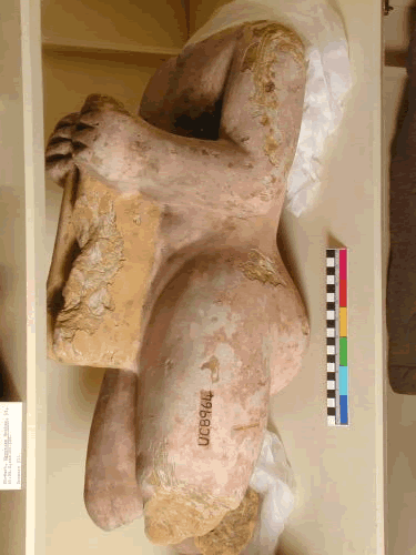
Ceramic statues of the god Bes and his consort Beset found associated with the shrine (scale bar 500mm).


http://www.sudarchrs.org.uk/wp-content/uploads/2014/06/Kawa_QSAP_English_booklet.pdf
Excavation and survey at Kawa
 

Misreeya

Pro
Joined
Jun 13, 2015
Messages
1,663
Reputation
-90
Daps
2,135
Reppin
Sudan/New Zealand.
Sarcophagus of King Aspelta


SC80.jpg


Granite coffin and lid of King Aspelta. On top of lid the lower parts of a hawk and jackal, the upper parts missing.

Provenance
From Nuri, tomb of Aspelta (hawk figure from tomb of King Amtalqa). 1916: excavated by the Harvard University-Museum of Fine Arts Expedition; assigned to the MFA in the division of finds with the government of Sudan; 1923: received by the MFA.

Credit Line

Harvard University—Boston Museum of Fine Arts Expedition


D1545.jpg


D1547.jpg


D1548.jpg


D1549.jpg


D1552.jpg


D1550.jpg


D1551.jpg

Sarcophagus of King Aspelta
 
Last edited:

Misreeya

Pro
Joined
Jun 13, 2015
Messages
1,663
Reputation
-90
Daps
2,135
Reppin
Sudan/New Zealand.
Sai Island Sudan, this site in Northern Sudan is very ruin. The earliest period of this site is during the New Kingdom period during the period of King Tut and those before the boy king. This site was later occupied by the Ottomans, when the Ottoman empire rule what is now Egypt and parts of Northern Sudan, whereas the Funj ruled what is today central Sudan.

attachment


Ile_de_Sai_ville_pharaonique.jpg


sai-island08.jpg


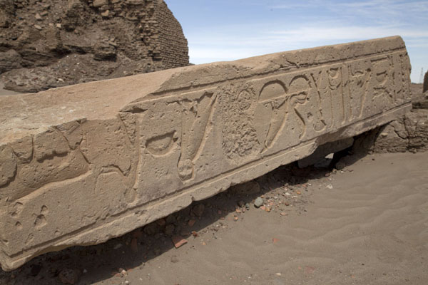
Obelisk


old-temple-ruins-sai-island-sudan-d69bkt.jpg


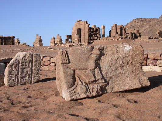
Obelisk decorated with hieroglyphs lying on the ground of the Ottoman fort | Sai Island | Sai | Travel Story and Pictures from Sudan


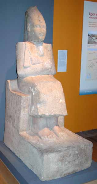
Statue of Amenhotep from Sai island

bm%20sudan%20exhibition,%20jan-05%20077.jpg


another statue of Amenhotep found also in Sudan Kumma Temple

463022035.jpeg


Statue of Amenhotep I, white crown and heb-sed cloak from the Island of Sai
 

Bawon Samedi

Good bye Coli
Supporter
Joined
Mar 28, 2014
Messages
42,413
Reputation
18,635
Daps
166,508
Reppin
Good bye Coli(2014-2020)
Like I said MORE work needs to be done in the Sudan and other parts of Africa. You would think these archaeologist who are obsessed with Egypt would be doing excavations in the Sudan to find out more about Egypt since the two cultures were highly connected, and yet the Sudan is barely even dug up.
 

Misreeya

Pro
Joined
Jun 13, 2015
Messages
1,663
Reputation
-90
Daps
2,135
Reppin
Sudan/New Zealand.
Like I said MORE work needs to be done in the Sudan and other parts of Africa. You would think these archaeologist who are obsessed with Egypt would be doing excavations in the Sudan to find out more about Egypt since the two cultures were highly connected, and yet the Sudan is barely even dug up.

Actually work is being done especially the monuments i posted here. How you think i was able to post some of the monuments without the information from Archaeologist you just have to view the links i posted, because work was and still being conducted. Most of the excavations is being conducted by(Americans, British, Italians, Russians, Egyptians, Japanese, Polish(mainly christian sites) Gulf Arabs and of local Sudanese) Archaeologist. Why do you think there is a dedicated department of Archaeology at the University of Khartoum. As i told you before, good percent of the New Kingdoms monuments is mainly in Upper Egypt and what is today Northern Sudan, hence the reasons why they conduct many excavations in sites such as Amara West, Kawa, and Jebel barkal. It is out there but you have to just look for it. LOL


P.S.

Lastly many of these statues and objects posted here are in your museums in America.

Take a look at the looks,


Sarcophagus of King Aspelta
 

Misreeya

Pro
Joined
Jun 13, 2015
Messages
1,663
Reputation
-90
Daps
2,135
Reppin
Sudan/New Zealand.
I am going back to El kurru ruins and mortuary temple. The reason why i a reposting this again, i love how the Getty museum photograph the temple in almost a HD TV way, if that makes sense.


A view of part of the Al-Kuru archeological site, more than 300 kms northwest of the Sudanese capital Khartum on March 24, 2014. Teams from both Sudan's Dongola University and the USA's Michigan University have been excavating the site uncovering this season a temple with 23 interior columns. It is not yet known when the columns were built, but it is believed they are linked to a near by cemetery which contains some graves which appear to date from before the start of the Napatan kingdom in 750 BC, according to Abbas Zarook, head of the joint mission. There are also the remains of pyramids linked to the family of Napatas greatest king, Piankhi, whose tomb was recovered years ago by a different American archaeologist team. With financial support from Qatar, the Sudanese-American team is continuing to excavate the 17 pyramids.

stairs-and-a-tunnel-as-photographed-at-the-alkuru-archeological-site-picture-id481516087


worker-digs-at-the-alkuru-archeological-site-more-than-300-kms-of-picture-id481516043


workers-remove-earth-at-the-alkuru-archeological-site-more-than-300-picture-id481516057


view-of-part-of-the-alkuru-archeological-site-more-than-300-kms-of-picture-id481515977


hieroglyphics-decorate-a-wall-at-the-alkuru-archeological-site-more-picture-id481516093


light-is-shone-on-hieroglyphics-at-the-alkuru-archeological-site-more-picture-id481516407


light-is-shone-on-hieroglyphics-at-the-alkuru-archeological-site-more-picture-id481516115


light-is-shone-on-hieroglyphics-at-the-alkuru-archeological-site-more-picture-id481516123


A view of part of the Al-Kuru archeological site, more than 300 kms northwest of the Sudanese capital Khartum on March 24, 2014 Pictures | Getty Images
 

Misreeya

Pro
Joined
Jun 13, 2015
Messages
1,663
Reputation
-90
Daps
2,135
Reppin
Sudan/New Zealand.
Excavation of a tomb of a Queen Khennuwa in the pyramid complex of Meroe.

rem1.jpg


After almost a century, archaeologists are re-entering the burial chambers of the mysterious Queen Khennuwa, who remains a mysterious personality of the Kingdom of Meroe.
The archaeologists re-opened the tomb to increase documentation and research on the queen and site. According to Heritage Daily , the burial chambers were completely decorated with executed paintings and hieroglyphic texts, many of which are still in a good state of preservation. It was identified as the tomb of Queen Khennuwa due to the inscriptions in hieroglyphic texts.
The pyramid of Queen Khennuwa was excavated in 1922 during the excavations in ancient Nubia by George A. Reisner of the Boston Museum of Fine Arts. However, the documentation created by his team wasn't complete, it contained only a few photographs and a few hand copies of inscriptions. This lack of information about the burial led archaeologists from the Qatari Mission for the Pyramids of Sudan (QMPS) to ask for permission to re-open the tomb.
- See more at: http://www.ancient-origins.net/news-....krf4JDEB.dpuf


http://www.ancient-origins.net/news-...hennuwa-005405


http://archaicwonder.tumblr.com/post...a-investigated
 

Misreeya

Pro
Joined
Jun 13, 2015
Messages
1,663
Reputation
-90
Daps
2,135
Reppin
Sudan/New Zealand.
Ancient City of Dangeil today North Sudan. It is a interesting read of the large preserve temple of Amun, and city itself which was buried in the sands and well preserved

Dangeil, Sudan


309.jpg

Journey to Dangeil

In 1997, we began archaeological reconnaissance in the region around Dangeil, an area just south of the Fifth Cataract of the Nile, approximately 350km north of Khartoum. Dangeil is an important crossroad, situated at the hub of ancient and modern trade routes connecting the life-giving Nile with the eastern and western deserts and the Red Sea to the east. The sharp rocks and rapids of the Fifth Cataract form a physical boundary that restricts travel along the river, and which, in the past may have defined other borders: the southern-most limit of the Ancient Egyptian empire was a rocky outcrop called Hagr el-Merwa, located just north of the Fifth Cataract, while the great Late Kushyte royal city of Meroe is situated just upstream of the cataract, to the south. As throughout much of Sudan, archaeological work around Dangeil has been limited. Vital clues and teasing hints were provided in 19th and early 20th century AD reports made by members of the Turkish army and early travellers, mentioning archaeological sites in the area.

Key sites around Dangeil include a large fortress dated to the 4th-5th century AD, and an extensive tumuli field of the same date, extending over 3km and containing several hundred burial mounds. One of the most outstanding and substantial archaeological sites in the area is a Late Kushyte city (3rd century BC – 4th century AD) situated within the modern village of Dangeil. However, it is under threat from the expansion of the surrounding modern community and neighbouring agricultural projects. This city has therefore become the recent focus of our research. Late Kushyte culture, as represented by Dangeil city, exhibits a rich mixture of Pharaonic, Graeco-Roman and indigenous African characteristics. This richness is related to the broad cultural contacts of the Kushyte Empire. Throughout its existence (9th century BC – 4th century AD), the empire maintained close relations with Egypt, but at its zenith, in the 8th century BC, its dominion stretched from the borders of Palestine possibly as far as the Blue and White Niles and united the Nile valley from Khartoum to the Mediterranean.

The Lake Kushyte city of Dangeil

We established that the late Late Kushyte city at Dangeil covers an area of roughly 300m x 400m. ‘Dangeil’ means broken red brick in Nubian and many red brick and mud brick fragments, plaster, Late Kushyte pot sherds and large numbers of bread moulds cover the surface.

With several large individual mounds, rather than a single mound, Dangeil city has an unusual appearance that has puzzled modern archaeologists. Many mounds stand over 4m high. After excavation we discovered that each mound was in fact an individual, well-preserved building. The site of Dangeil city has no parallel in Sudan.

Our excavations began on one of the large mounds, known as Kom H, in the centre of the site. Initially, we uncovered a red brick surface, which we thought to be a floor; however, it was quickly realized that we were in fact standing on the uppermost part of a building.

We had, in fact, revealed one-half of a huge redbrick pylon gate belonging to a previously unknown temple to the god Amun. The origins of this ram-headed god are obscure, but he was an important creator god in both Ancient Egypt and in the Sudanese Kushyte kingdom and he bestowed the mantle of kingship upon the Kushyte kings.

The Kushytes believed that the home of the god Amun was in the mountain of Jebel Barkal, near the 4th Nile Cataract. Such was Amun’s centrality to Kushyte beliefs that in the mid 8th century BC, the Kushyte kings invaded and conquered Egypt as champions of the god Amun. These kings are known in Egyptian Pharaonic history as the 25th Dynasty. Of them all, King Taharqo is the most famous, and is mentioned in the Bible. However, after ruling for around a hundred years in the 8th century, the Kushytes were expelled from Egypt by the Assyrians. Nonetheless, the Kushyte kingdom flourished in Sudan for another 1000 years, remaining powerful, and maintaining close contacts with Egypt.

Uncovering divine history

Our excavations bisected Dangeil’s Amun temple along its processional axis. We established that it was orientated east-west with the entrance facing the Nile and that it is quite big: approximately 48.5m east-west by 33.5m north-south. The walls are largely built of red and mud bricks and the roof was held up by columns with drums made of red brick quarters or thirds.

Carefully laid sandstone flagstones of varying sizes were used as flooring in the central corridor, its second court and sanctuary. Long depressions are visible in the floor of the second court. These appear to correspond to the placement of the temple’s roof beams and were probably caused by rainwater leaking through the roofing and dripping from the beams onto the soft sandstone floor. Though the region receives only 25mm of rain per year, it tends to fall all at the same time.

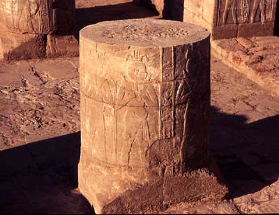
Graffiti were also inscribed on this floor. These included the Meroitic letter ne inscribed in a box, and the footprint of a pilgrim. We remain unclear on the meaning of ne: Meroitic, is the local written language of the Kushytes, and is yet to be deciphered. As for the footprint, we often find images of feet or sandals inscribed in or near to holy places, created as a marks or expressions of piety, during the Late Kushyte period. The sanctuary was buried beneath fallen sandstone blocks and pieces of the chapel facings. With the sanctuary exposed, four decorated sandstone columns, and two altars were visible along with three chapels. Unlike the rest of the temple, the sanctuary columns consist of sandstone drums stacked one upon the other, with a thin paste of mud mortar sealing them together

Each is decorated with eight fertility figures striding forwards toward the main altar. Each figure wears a headdress of Nile plants and carries two jars from which are pouring offerings of water or milk to Amun. One of the altars was also decorated with these fertility figures. Moreover, from within the temple sanctuary we found painted wall plaster fragments containing a vertical column of Meroitic hieroglyphs along with portions of the lotus flower headdress and hair of a fertility figure. It appears that fertility figures pouring offerings were painted in the lower register of the sanctuary walls, presumably striding towards the main altar, just as their counterparts on the columns do. Pieces of painted plaster found on and within the mound suggested that the temple and associated buildings had once been brightly decorated.

Breaking bread: an ancient ritual

The remains of three altars and a raised dais were discovered within the Dangeil temple. A range of evidence indicates that offerings including water, milk and bread, formed a major component of Kushyte worship and ritual. At Jebel Geili, 120km east of Khartoum, a victory relief of the Kushyte king Sherkaror (20- 30 AD) shows a god giving the king prisoners and a head of sorghum, a cereal from which breads and porridges are made. Bread was also baked in temple ovens. It would be offered to the god who, so the worshippers must have believed, would consume its spiritual essence. Presumably afterwards, the physical bread itself would be eaten by the priests and variously appropriate persons.

Among the bread mould sherds, we discovered an interesting ostracon. A black grid was painted on the pot sherd and a Meroitic number, usually one or nine, was written within each box. While the meaning of these numbers is uncertain, it seems likely that the bakers were recording batches of bread or an ingredient used in bread production. It is not certain whether the grain used to make the bread was emmer wheat or a free-threshing wheat. In any case, the cone-shaped loaves produced would have been rather dense. The results of our archaeobotanical studies are eagerly awaited in the hope that this question can be answered and some light cast on the origins of various crops in East Africa.

Returning to the temple sanctuary, within its fill, we found more evidence for ritual activity, including fragments of incense burners, ankh-shaped offering trays (the ankh is a round-topped cross and the Egyptian symbol for life), and a palette – perhaps for grinding the god’s cosmetics, plus numerous pieces of a finely carved, pink sandstone altar. Some altar fragments contained the names of the 1st century AD Kushyte queen Amanitore, written in Meroitic hieroglyphs and enclosed in cartouches. Clearly, she was a major benefactor of the temple and may have founded it or substantially renovated an existing structure, together with her king Natakamani. Interesting, then, that fragments of her altar are to be found in the sanctuary’s fill.

Iconoclastic catastrophe

In fact, we found the core of the Amanitore altar among the debris within the central sanctuary. It had been purposefully smashed, broken in two and all decoration chipped off, leaving two rather sad, rounded boulders.

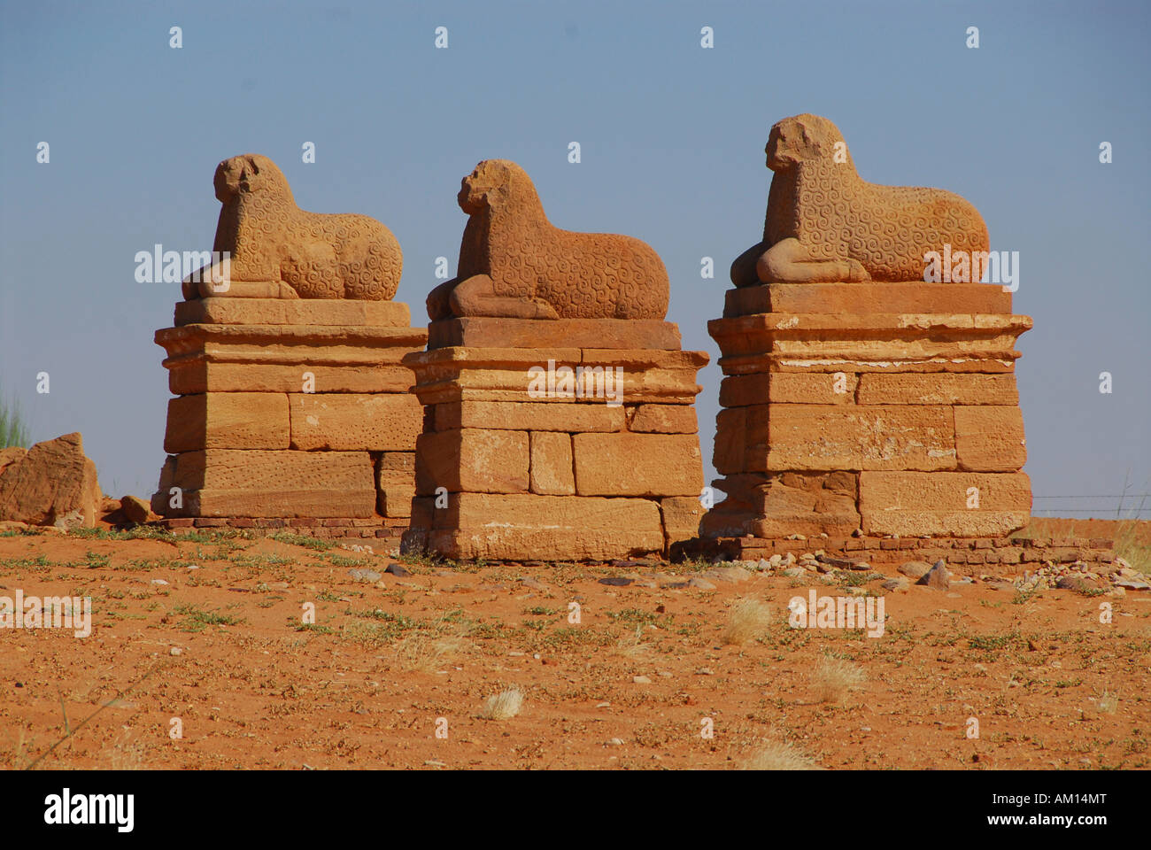
Further evidence of destruction emerged when we unearthed part of the avenue leading from the temple to the main gate in the temenos (surrounding) wall. We found a series of statue pedestals flanking the road on either side; but no statues. Sandstone fragments of ram statues, including eyes and fleece, show the statues too were smashed in a fashion similar to that of the Amanitore altar.

Finally, a major fire had ripped through the temple. We found extensive remains of charred roof beams and roofing material just above floor level in every room of the temple. Following this dramatic burning, the temple slowly collapsed in on itself and appears largely abandoned. The cause or instigator of the fire is unknown. However, the stratigraphy indicates that the Amanitore sandstone altar in the central sanctuary, and perhaps also the rams flanking the processional way, were smashed just before this fire occurred. This suggests that the temple was destroyed on purpose.

The end of the Kushytes, the end of Dangeil city

The end of the Kushyte kingdom in the 4th century AD has been much debated and remains unclear. Based upon inscriptional evidence, it has been suggested that the Axumites from Ethiopia attacked and sacked the Kushyte royal city of Meroe in the 4th century AD.

This may have contributed to or sealed the collapse of the kingdom, but whether Dangeil provides actual archaeological evidence of this event is uncertain. Little evidence of such an event has been recovered from Meroe itself.

We plan to continue our excavations and fieldwork at Dangeil during the autumn of 2006 in the hopes of answering some of these questions. Sizeable areas of Dangeil and its associated cemeteries remain unexplored and appear substantially preserved.

As such, Dangeil provides a unique opportunity in Sudan to study the characteristics of a Late Kushyte temple complex, its cult rituals and the surrounding settlement, thus enabling a better understanding of Late Kushyte society and lifestyle some 2,000 years ago.


Now this throw away the myth in regards of people mainly living in huts, some of it is true, but many people also lived in city as well. This shows a variety of different lifestyles in antiquity from the simple to the complex.
 
Last edited:
Top